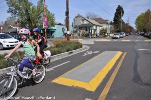
A Look at the ‘Next Generation’
A Look at the ‘Next Generation’
City Shares Its Toolkit for Sanchez Slow Street
By Chris Faust 9/27/2023 Photos by Chris Faust
(This story appeared in part in the October 2023 issue The Noe Valley Voice, printed Oct. 6, 2023.)
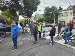
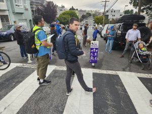
On the evening of Sept. 14, six San Francisco Municipal Transportation Agency (SFMTA) employees in bright yellow vests waited at the intersection of 30th and Sanchez streets while about 60 neighbors congregated. The spirit of the gathering was as warm and congenial as the evening air. Laughter and pleasantries greeted new arrivals.
Slow Streets team member Matt Lasky began to distribute a one-sheet handout, saying, “Whatever we can do to make it better, we are here to listen.”
He referred to his sheet as the toolkit. It consisted of pictures and descriptions of the six different treatments being proposed for slow streets: Community Zones, Neighborhood Traffic Circles, Landscaped Islands, Roadway Narrowing, Wayfinding and Identification Signs, and On-Street Bike Parking.
SFMTA billed the event as the “Next Generation Sanchez Slow Street Community Walkthrough.” They invited anyone in the city to come and see what might be next for their slow street. Slow Streets program manager Mark Dreger introduced his team.
“We’re happy to take your comments and listen to you. A lot of people are using it, walking, biking, enjoying the street. We’re going to talk about the next level of what it could be. That includes more placemaking, like paint on the street or places to sit, places to talk. I know there are a lot of mixed feelings. I don’t know about here tonight, but there are mixed feelings about slow streets. They have been adopted, like Sanchez, by the SFMTA board, who is our ultimate boss. Whatever we can do to make it better, we’re here to listen.”
With that, he introduced Alejo Alvarado, project manager for the Next Generation Slow Sanchez Street project, who said, “As we walk through intersection by intersection, block by block, we want to get your feedback on your general experience on the street and get feedback about these specific tools. The next step will be designing a couple of different proposals for the street.”
With an understanding of the features in hand, we divided by birthdays into three groups, taking the left, right, and center of the street. Former Slow Streets program manager Shannon Hake and traffic engineer Ellen Robinson led our group of 20. We introduced ourselves and mentioned our interest in this event. Almost all members of our group live on or near Sanchez Street. Most said they used it daily or frequently, and voiced support for Slow Sanchez. A couple mentioned that walkability and Slow Sanchez were factors when moving to the neighborhood. A few called for the need to make it safer or friendlier to children.
Several expressed room for improvement. They said it could be frustrating navigating the street to come and go from their homes and do chores, or that the street was becoming a parking lot. We moved on.
Sanchez the Best Performer
The groups moved north roughly together, demonstrating the huge capacity of this broad street and spacious sidewalks. The goal was to reach the end at 23rd Street in one hour, which seemed ambitious, and turned out to be so.
Hake addressed the need for this event here rather than at some less-performing location. Currently, Slow Sanchez out-performs all other slow streets, according to the 2023 Slow Streets Evaluation Report of May 2, 2023, with speeds well under the target typical median vehicle speed of 15 mph (Sanchez was 13 mph) and average daily traffic of 1,000 vehicles (Sanchez had 320).
Said Hake, “We are now looking not only at meeting the speed and volume thresholds but at how to make it work as a place. Slow Streets are not just transportation. They are also community spaces. We are trying to figure out how to improve them and make them work for all residents. The funding came from District 8, so this is a priority for District 8 as well.”
The Gateway at 30th Street
The first stop was Day and Sanchez, which has a heavy mix of vehicle, pedestrian, and other traffic associated with the busy recreation center, which serves the entire city. Car traffic can be heavier than at other locations along Sanchez with parents circling around to pick up and drop off children throughout the day.
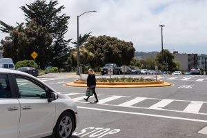
Participants asked about various features for this intersection and Hake provided her expertise. Speed bumps are not appropriate for Sanchez in general since bumps are designed for 17 mph; traffic here is already below that. Small bumps near intersections were suggested to remind speeding scooters of approaching cross streets; Hake took note. What can be done about outlier speeds and cars taking corners too fast? Corner treatments to narrow the road might work here. Perhaps even a traffic circle. Robinson explained that traffic circles are not roundabouts. They retain stop signs. They would be small enough to fit within the existing intersection structure and accommodate certain vehicles sizes.
Hake addressed a question about using concrete median diverters to slow traffic. Those were being considered on some underperforming slow streets but not here, she said, although there was a potential to do something at 30th Street as a gateway treatment.
Robinson answered questions about whether any of the features would affect access by fire trucks or delivery trucks. “Nothing we propose is something we don’t think we can make work for emergency access to the street.”
Bulbouts or Street Murals
Moving on down the street, we took stock of each intersection. At 29th Street, neighbors mentioned that Alice’s Restaurant did a brisk takeout business, which brought a lot of cars turning quickly onto Sanchez and stopping and parking there. Hake suggested Community Zones could be one of the features used to bulb-out the intersection. At 28th Street, Hake suggested a similar treatment.
Ideas started to pour out. One neighbor suggested painting street murals that would run the length of Sanchez to indicate more clearly the community-orientation and child-friendly nature of the street. Another suggested painting intersections to make them stand out as different from other street corners. Someone else suggested brightly painted indicator zones to remind kids to slow and stop at intersections. Another offered an idea to paint a separate biking area for kids to the sides of the road versus “the road” that they should avoid. “Kids don’t read, so use paint.” Someone else wanted to put art at intersections.
Busy Intersections
The tone changed at Duncan Street. The street is a dead-end west of Sanchez. Drivers there have no other choice but to cross Sanchez and that has presented issues. Participants in our group related tales of bitter confrontations, with pedestrians screaming at drivers entering and leaving the street, taking pictures of their license plate, blocking passage, or kicking doors.
Hake was reminded of the Slow Street Program’s How to Use Slow Streets Fact Sheet and its messages urging everyone to get along. Someone suggested art that reminds users to be kind to the residents, such as “We all live there together.” Such signs already exist, according to Hake, and can be adapted to Sanchez. They say, “This is Your Slow Street. Everyone is Welcome. Go Slow.”
Cesar Chavez was noted for being a very busy cross street that might benefit from a traffic circle. 26th Street is also very busy but has an unusual set of challenges. Many lines of underground utilities come together here which limit landscaping and curb change treatments. Lots of fire truck traffic from 26th Street station passes through. In addition, this is the site of the Noe Café and identified as a community center. Many kids are present. Things like painted Community Zones would be most appropriate, according to Hake.
Clipper and Sanchez is another of the busiest intersections, but it also has the least space. It is too narrow for a traffic circle. We discovered a crushed street planter here, perhaps emphasizing the limited room and the need for special features.
An hour and a half after starting, the tour stopped at 24th Street. Folks had the opportunity to chat with members of the other groups and compare notes. There was some question about whether efforts had been made to determine the will of residents, particularly Sanchez residents. Another expressed concern that information about Slow Sanchez was confusing as to whether plans were simply ideas or actually happening. One resident exclaimed, “People are using it, cars are trying to get across, so how do you make it better for the cars and pedestrians?” Another said, “Take streets back from cars!” A third smiled and said, “This strip has its own vibe.”
Wrapping Up
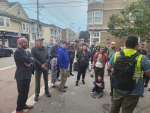
Supervisor Rafael Mandelman and District 8 legislative aide Adam Thongsavat ambled their way up the street behind us. Mandelman addressed the crowd. “First, we worked to make it a slow street and then working to make it a better slow street. The tale of slow streets over the last few years has been mixed around the city, and the success of these experiments has depended on whether the community wants it or not and the extent that the community is willing to engage and make these places great.
“I feel fortunate to have represented an area that wanted to make this street great,” he continued. “I know the MTA enjoys working with a community that is not at each other’s throats about it and is able to work out some of the compromises and challenges and different interests that folks have.”
He then credited Thongsavat for suggesting the use of funds to improve Slow Sanchez, when money was discovered in January 2023 He was referring to the $277,300 in Proposition K transportation sales tax funds earmarked for District 8.
Still Tinkering With Design
On Sept. 20, Dreger and Alvarado returned to the neighborhood to address an audience of 40 at the regular Upper Noe Neighbors meeting at the rec center. Five attendees indicated that they were also at the walkthrough event.
The two Slow Street managers did their best to reenact the event using Google Streets to visualize the Sanchez Street intersections. It quickly became clear that their walkthrough experience, with different groups of citizens, was unique. Many of their suggestions for features were different from those proposed in Hake’s group. This bolstered the Slow Street team’s statements that they did not have a fixed idea of what they might design for Slow Sanchez.
Dreger said they would present their proposals in the next couple of months. He repeated that they welcomed further input. As they said, they were here to listen.
Contact:
Email them at SlowStreets@SFMTA.com.
Get more information at SFMTA.com/projects/sanchez-slow-street .
Features:
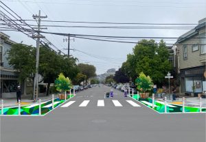 Painted Safety Zones / Community Zones help to increase the visibility of pedestrians at intersections and to encourage slower turning speeds. These painted areas of the road wrap around sidewalk corners to make pedestrians crossing intersections more visible to drivers. The narrow intersection also decreases the crossing distance for pedestrians. These zones can be used for street murals, potted plants and other community uses. They may require parking removal.
Traffic Circles, unlike roundabouts, would maintain stop signs at all four corners if implemented on Sanchez Street. They slow vehicle speeds at an intersection by preventing drivers from traveling straight through. They also provide better cross-street visibility. They can be built of concrete or other materials like safe-hit posts and paint. Depending on materials used, this feature may require more maintenance and take longer to install. The cost is estimated at between $50,000 to $60,000 apiece. No more than two are proposed for San
Landscaped Islands are concrete islands that provide a more durable barrier to discourage cut-through vehicle traffic. On Sanchez they would be used to inhibit cars from turning too sharply. These features work best on streets where there is sufficient space to maintain vehicle access in the opposite direction. Street sweeping and drainage must be considered for concrete islands located close to the curb. Concrete materials last longer, require less maintenance, and act as a more robust barrier for discouraging cut-through traffic than typical Slow Streets delineators, while allowing for bicycle and scooter access. Where possible, the islands could include space for community art and greening.
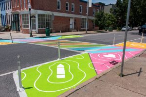 Roadway Narrowing uses striping and/or vertical elements to visually and physically narrow the right of way to help reduce vehicle speeds. It can use striping, bollards, and signage. This feature can provide space for community art and greening. Removal of parking spaces may be required.
Slow Street Wayfinding and Identification Signs indicate the location of a Slow Street for approaching motorists and people walking, biking, or rolling. Like Slow Street pavement markings, Slow Street identification signs reinforce the character of the street as a place where all users should be traveling at slow speeds. The newer signs include cars to help users be aware that this is a shared street.
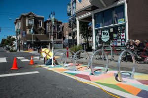
On-Street Bike Parking provides parking for cyclists visiting the neighborhood and prioritizes roadway space for active transportation uses. On-street bike parking can also narrow the roadway to calm traffic. This tool can be co-located with Painted Safety Zones/Community Zones or Roadway Narrowing along the Slow Street. Removal of parking spaces may be required.

